Discover Heritage Hiking Trails
HERITAGE HIKING TRAILS
-
The easy, 1.5km graveled Frank Slide Trail begins and ends at the Frank Slide Interpretive Centre parking lot and winds through the edge of the famous Frank Slide, giving visitors an up-close look at the awesome power of nature. An interpretive guidebook to the trail is available from the Centre, which is open year-round, with notes corresponding to several concrete markers along the way. The Frank Slide Trail shares its trailhead with the Frank Slide North Rim Trail; both are components of the Crowsnest Pass Community Trail system.
In the early morning of April 29, 1903 the face of Turtle Mountain collapsed, sending 87 million tonnes (30 million cubic metres) of limestone crashing down across the valley. The slide destroyed the Frank Mine surface plant, buried the CPR rail line and killed approximately 90 people on the outskirts of the town of Frank. However the mine was reopened within weeks, and the CPR rail line was pushed through the slide within a month. The Frank and Grassy Mountain Railway was forced to switch-back across Gold Creek when the slide obliterated its connection to the CPR main line; the Frank Slide Trail follows a short section of this railbed.
The many tales of tragedy and survival are documented in the interactive exhibits and media presentations at the Frank Slide Interpretive Centre. -
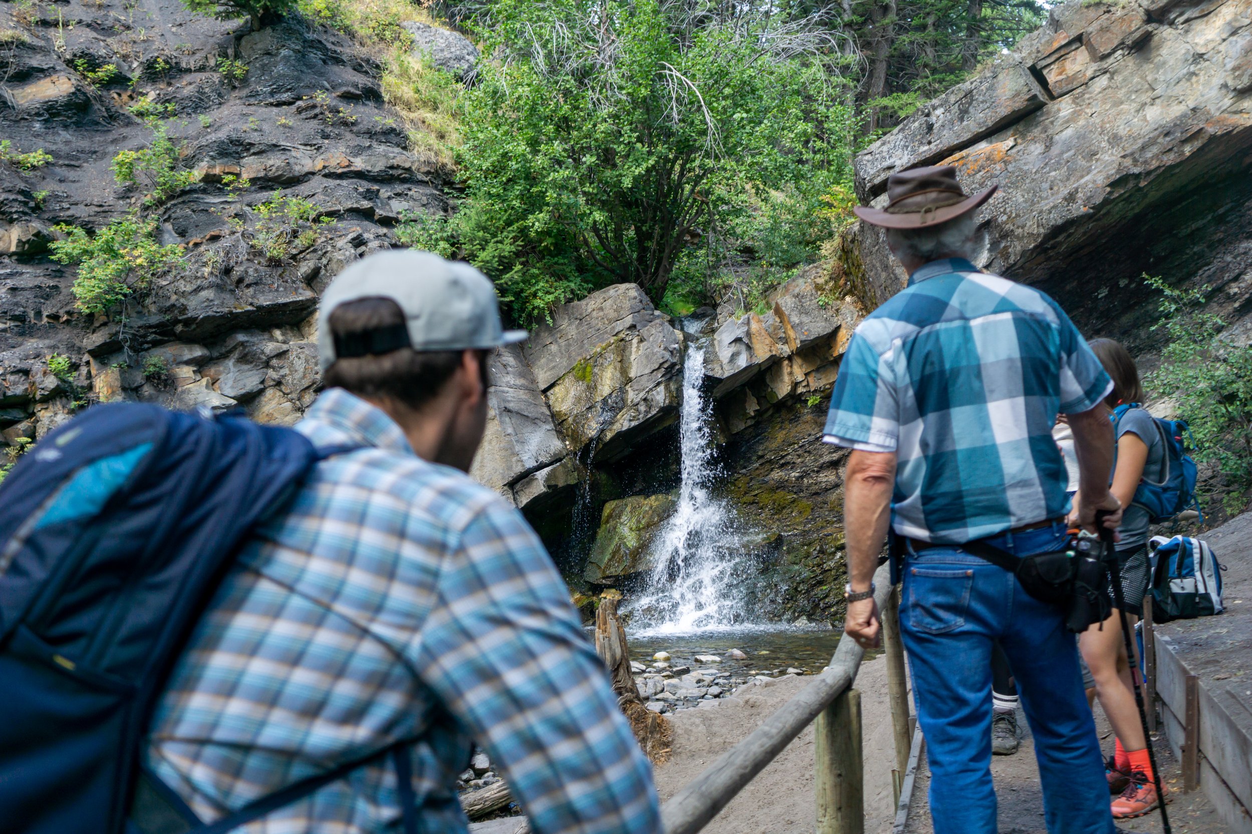
The Miners Path was the historic route taken by Coleman miners on their way to work at the McGillivray Mine between 1909 and 1957. Up to 200 miners on each shift would walk the trail at all times of the year. Remnants of an electric lighting system installed in the 1940s for the night shift are still visible along the trail.
The trail is now maintained by the Coleman Lions Club as a scenic/recreational walking trail. This easy, pleasant trail begins at Flumerfelt Park in Coleman and follows Nez Perce Creek for one kilometer to Rainbow Falls. The trail branches at the 0.4km mark where a bridge crosses the creek and leads steeply up stairs to the old McGillivray Mine site, which still has remnants of a bygone coal mining era. Please do not disturb any artifacts.
Follow directional signage on Highway 3 in Coleman, and park at the far end of Flumerfelt Park next to trailhead signage. An interpretive pamphlet that describes the old mine site is available from the Crowsnest Museum, also in Coleman. -
The remote location of the old Lille townsite is testament to the energy and risk-taking of the turn-of-the-century coal entrepreneurs. Originally called French Camp, Lille was renamed after the mine owner’s home town in France, and thrived for ten short years from 1902 to 1912. Lille was originally served by a trail, then a wagon road, and eventually the Frank and Grassy Mountain Railway line up Gold Creek from Frank that included several switchbacks and twenty-three wooden trestles across Gold Creek. After the mine failed in 1912, all the buildings in Lille were eventually dismantled or moved to other locations in the Pass. The railway trestles were also removed, and by 1937 the last of the rails were gone.
In 1978 Lille was declared a Provincial Historic Site, primarily to protect the impressive ruins of the fifty-bay Bernard coke ovens. These ovens were designed and constructed in Belgium, then shipped to Lille in 1903 or 1904 where each numbered brick was reassembled. Other signs of Lille town-site include the massive stone foundation of the hotel, the outlines of smaller foundations, a few fire hydrants, and heaps of coal slack. The ruins of a large power house are encountered on the hike in. Please do not disturb any of the ruins or artifacts.
The 6.3km moderately difficult Lille Mines and Townsite heritage trail closely follows the original wagon road, and in places crosses the roadbed of the old Frank and Grassy Mountain Railroad. Access is via the Frank Slide Interpretive Centre paved access road. At the hairpin turn, drive over the cattle-guard onto the gravel road, and turn left after about 0.25km and park in the meadow. Hike on the rough road into the forest and turn left after about 1.5km where you rejoin the main Lille access road and follow it up the Gold Creek valley. A crossing of Green Creek brings you to an interpretive and directional sign just before the Gold Creek crossing, where you can visit the powerhouse at the No. 1 mine site. A second crossing of Gold Creek and a final crossing of Morin Creek brings you to the open meadow of the old town-site and another interpretive sign. Return the way you came.
The trailhead for the Lille Mines and Townsite Trail is 650m from another heritage trail, the Frank-Bellevue Wagon Road. -
n 1946 an RCAF DC-3 Dakota struck a mountain in bad weather and crashed near the headwaters of North York Creek, killing all seven on board. Remnants of the plane wreckage can still be seen via a moderately difficult hike of 6.2km each way. If you visit, please do not disturb any of the plane wreckage.
Take the York Creek Road south from Coleman, and park at the bridge over York Creek after approximately 4km. Hike across the bridge and follow the route that leads up the south bank of York Creek. The route eventually forks, and hikers take the right fork across York Creek and up the North York Creek drainage.
You may continue past the plane wreckage to pleasant meadows below Mt. Coulthard.
-
Phillipps Pass is in between Crowsnest Ridge and Phillipps Peak of Mount Tecumseh and, like the Crowsnest Pass, crosses the continental divide. In 1873 Michael Phillipps crossed this pass from west to east, the first white person to visit the area. A track was soon cut across Phillipps Pass, and in 1888 it was used by Colonel Sam Steele and the North West Mounted Police during the evacuation of Fort Steele.
With the development of towns in the southern Rockies, the Phillipps Pass track was gradually improved and became the first automobile road across the continental divide in Canada. On October 3 1912 Thomas Wilby and Jack Haney crossed it during the first ever trans-Canada drive from Halifax to Victoria. Parts of the route remained very rough, however, and the Phillipps Pass route was replaced by a good, graveled road blasted around Crowsnest Lake in 1921, which is the route followed by the present Highway 3.
Phillipps Pass was famously used by rum-runners to illegally import alcohol into Alberta during prohibition (1916 – 1921). Sometimes the rum-runners would pose as innocent picnickers, or sometimes they’d try to outrun the Alberta Provincial Police in their McLaughlan “whiskey sixes”.
The traditional Phillipps Pass trail on the Alberta side is a rough, graveled road with a long uphill section – but part of it runs over private land, and is at present closed to the public. Public access is only from the BC side, beginning at the Crowsnest Provincial Park day-use area off Highway 3 just two kilometers west of the Alberta border (at the Welcome to BC sign). The trailhead is not signposted, but is fairly obvious; a rough road makes its way directly up to Phillipps Lake. There is a vehicle trap at the beginning of the road, so plan to do the entire 3.2km of moderately easy but consistently uphill terrain on foot. Return the way you came. -
Chert is a colorful, hard stone used by ancient cultures for tools or for trade. Atop the Livingstone Range are shallow chert quarries worked by people of the Pelican Lake culture and their predecessors between 1,600 and 8,000 years ago. The quarries can be accessed by a challenging, 2.3km (each way) trail.
From the Frank Slide Interpretive Centre access road, take the graveled road off the hairpin turn, across a cattle-guard and up the hill, keeping right at the first junction and then turning left and then right onto the buried gas pipeline right-of-way (watch for the orange pipeline signs). Although it is possible to drive further with a 4WD vehicle, it is best to park here. Hike the steep road up the pipeline right-of-way to the windswept pass at the crest of the Livingstone Range, then make your way 0.5km south along the ridge crest to the base of the large electrical transmission tower. The quarries are found on the bench overlooking the Frank Slide about 50 to 100m southwest of the tower.The quarries themselves are unimpressive scoops in the ground, but chert is a very attractive stone with colors including white, pink, purple, red, brown and blue-black. Apart from its appearance, ancient peoples valued its smooth faces and sharp edges which could be worked into effective tools for hunting animals and working hides. This will become obvious as you run your fingers over the surface of the many chert stones lying about, but please leave them where they are for others to enjoy.
After taking in the panoramic views of the Frank Slide and Crowsnest River valley to the southwest, the Livingstone Range to the north, and the foothills to the east, return to your car the way that you came.
-
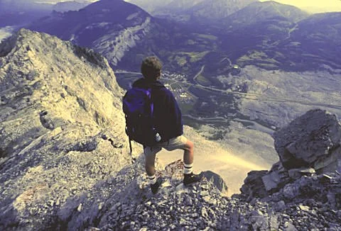
This very challenging trail gains 780m of elevation over its 3.1km one-way distance, but rewards hikers with stunning views from atop the Frank Slide. The trail follows the north ridge of Turtle Mountain from the Town of Blairmore to the north summit.
In the early morning of April 29, 1903 the face of Turtle Mountain collapsed, sending 87 million tonnes (30 million cubic meters) of limestone crashing down across the valley. The slide destroyed the Frank Mine surface plant, buried the CPR rail line and killed approximately 70 people on the outskirts of the Town of Frank. However the mine was reopened within weeks, and the rail line was pushed through the slide within a month. The tales of tragedy and survival are documented in the many interactive exhibits and media presentations at the Frank Slide Interpretive Centre.
It is not known who first ascended Turtle Mountain, although it must have been ascended many times after the railroad was completed in 1898. One famous ascendant was Edward Whymper, conqueror of the Matterhorn, who was in Frank in 1904 on a CPR-sponsored promotional tour of the Canadian Rockies. At age 64, it is probable that Whymper used this same north ridge route.
Take the back alley off 16th Avenue in Blairmore onto the pipeline right-of-way, and drive down towards Turtle Mountain to a parking area. Yellow-painted rocks indicate the start of the trail. Initially the trail is steep and rough as it fights its way up the west-facing ridge shoulder, but becomes a little easier once the ridge top is gained. The trail is generally well-defined throughout its length, but good scrambling and route-finding skills are required although no actual climbing is involved. The trail does come close to a number of sheer precipices, so those who do not like exposed views should not attempt this trail. The ridge and summit are notoriously windy, so please stay well back from the edge.
Along the summit ridge you can look down on the Frank Slide, the original 1901 Frank townsite (now an industrial park) and the present community north of the tracks, and also Blairmore and Bellevue. From the North Peak summit one has a commanding view of the surrounding mountains, and a little further along you can also see huge fissures caused by the release of the slide in 1903, and glimpse some of the monitoring equipment on the South Peak. Please do not tamper with any equipment. Return to to your car the way you came up. -
The Frank Slide of April 1903 severed communications between Frank and Bellevue and thus isolated communities in the upper Pass from the world to the east. Although the CPR rebuilt the rail link within a few weeks, it was essential that wagon and carriage access also be re-established. Accordingly, contractors Lund and Breckenridge (after whom the village of Lundbreck was named) were contracted in 1903 to build a wagon road north of the Slide, from the north edge of Bellevue to a connection with the road between Frank and Lille. After the construction of a new road through the lower Slide in 1906 (presently part of the Heritage Driving Route) the Frank-Bellevue wagon road fell into disuse, although it has been walked in summer and skiied in winter up to the present day, and also is part of UROC’s Slide Ride bike track.
This is an easy 2km (one way) walk on old roads. Drive the Frank Slide Interpretive Centre access road as far as the hairpin turn, and continue straight across the cattle-guard for 900m. Park in a clearing on the right, which is the trailhead. From here the old road heads south, uphill through trees, before picking up open terrain for about a kilometer. Many hikers follow the gas pipeline road, but the actual wagon road is about 30 metres uphill on the left. After entering trees, continue to follow roads southwards towards Fireman’s Park in Bellevue. You can end the hike here, but the actual wagon road continues up high, becoming an extension of 24 Avenue and joining Bellevue pavement at the triangular junction of 208 Street and 23 Avenue. You can hike back the way you came, or make a loop by either following the Community Trail from Fireman’s Park to the Frank Slide Interpretive Centre, or crossing east past the Bellevue water tank to an old road on the opposite side which runs north, roughly paralleling the Frank-Bellevue Wagon Road. Either way you’ll have to hoof a ways back to your car.